

The Rivers That Fly
High above the Amazon, invisible rivers carry more water than the Amazon itself. They were made by trees. And we are cutting them off.

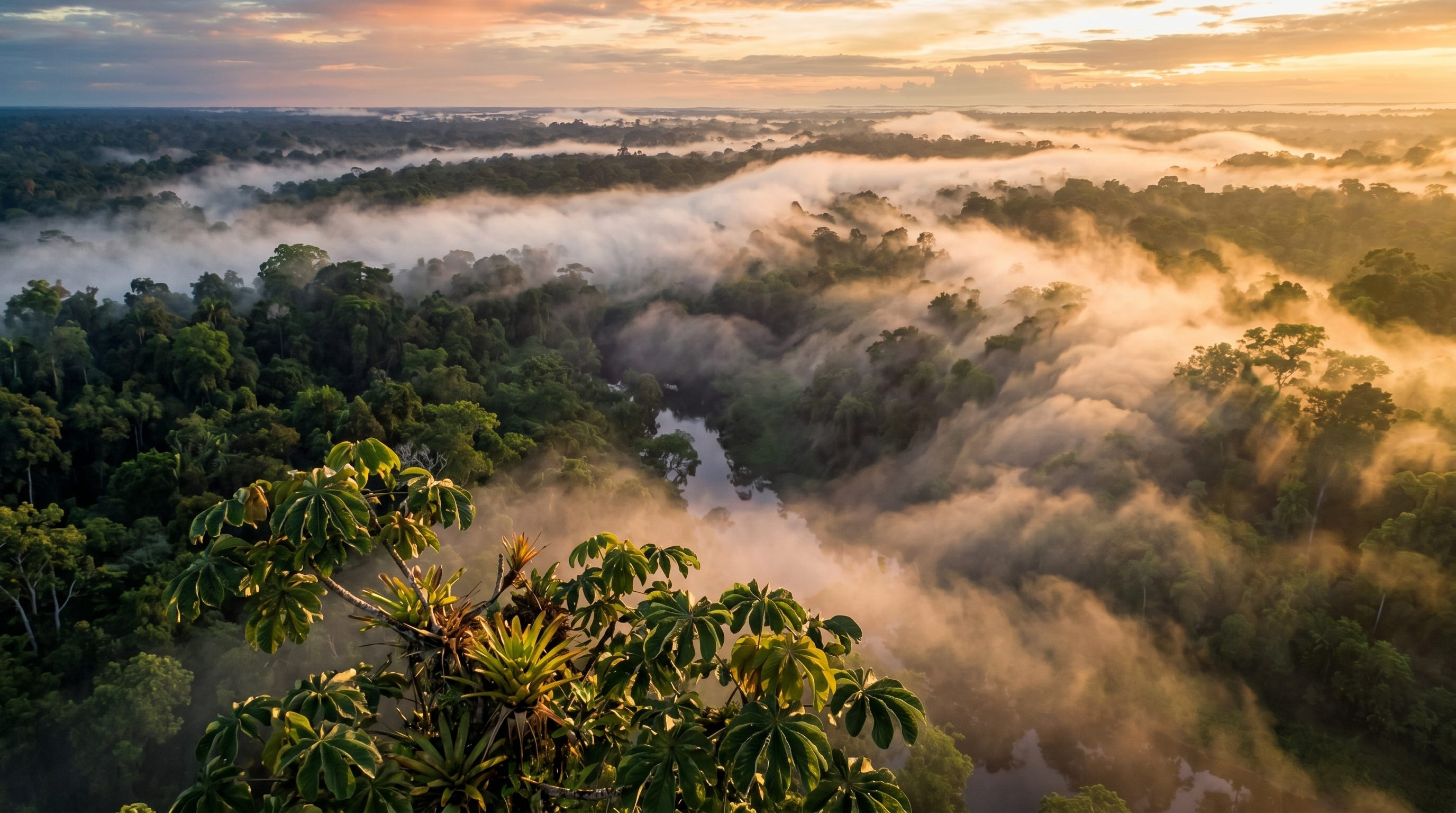
You cannot see them.
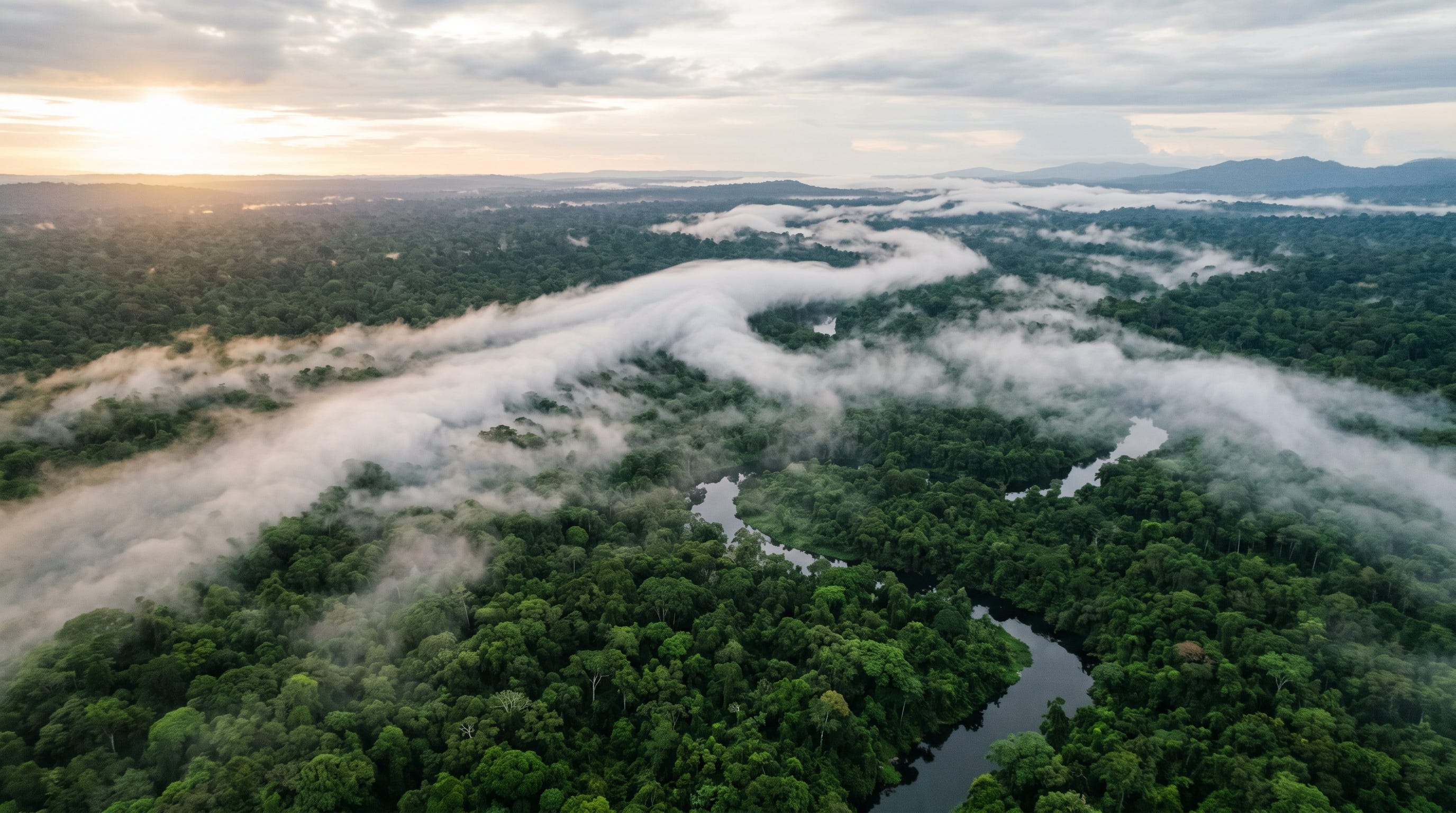
You cannot hear them. There is no instrument you carry in daily life that would register their presence. Standing in the Amazon in the dry season, your only evidence that something extraordinary is happening above you is the sweat on your back, the particular weight of air that feels less like air than like something you could wring out, and the clouds that appear each afternoon out of a sky that was clear at breakfast. They build from the east, towers of white against a blue so deep it looks painted, and by two in the afternoon they are releasing rain onto forest that has been releasing vapor into the sky since before the sun came up.
You are inside a machine. You just can’t see the gears.
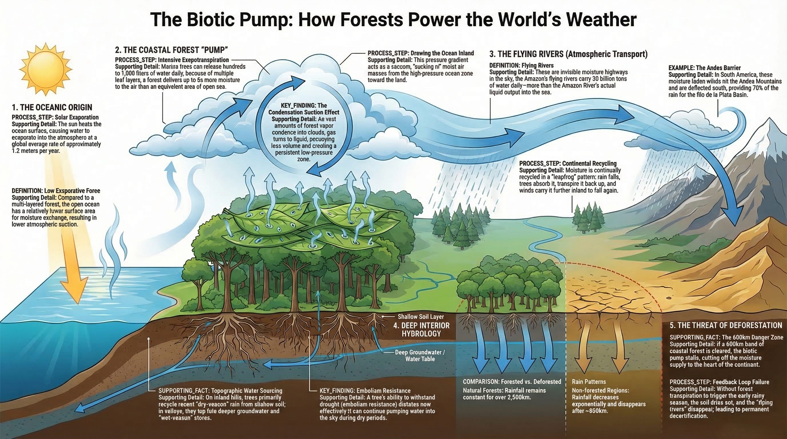
Right now, above the Amazon rainforest, rivers are flowing. Not the brown, powerful, sediment heavy rivers you can see and name and boat across. Those vast waterways that are familiar to us. These are rivers of a different kind. They are concentrated flows of water vapor moving through the lower atmosphere at an altitude of roughly a thousand meters, generated by the collective breathing of four hundred billion trees, traveling south and west toward the Andes and the La Plata Basin at speeds that would carry a cargo ship from the Atlantic coast to the interior of the continent in a matter of days.
Researchers who study them have calculated the flow rate. The aerial rivers above the Amazon carry approximately twenty billion tons of water vapor into the atmosphere every single day. The Amazon River itself, the largest river by volume on the planet, discharges approximately seventeen billion tons of water into the Atlantic Ocean every day.
The river in the sky is bigger than the river on the ground.
This is not a metaphor, and it is not a hypothesis, and the people who study it are not working at the fringes of atmospheric science. It is a measured phenomenon with a measured flow rate and a documented destination. Half of all the rainfall that falls on the La Plata Basin, the agricultural heartland that feeds Brazil, Argentina, Uruguay, and Paraguay, one of the most productive farming regions on earth, began as moisture exhaled by Amazonian trees. It traveled more than a thousand miles through the sky before it fell as rain on a soybean field or a cattle ranch or a city of eight million people.
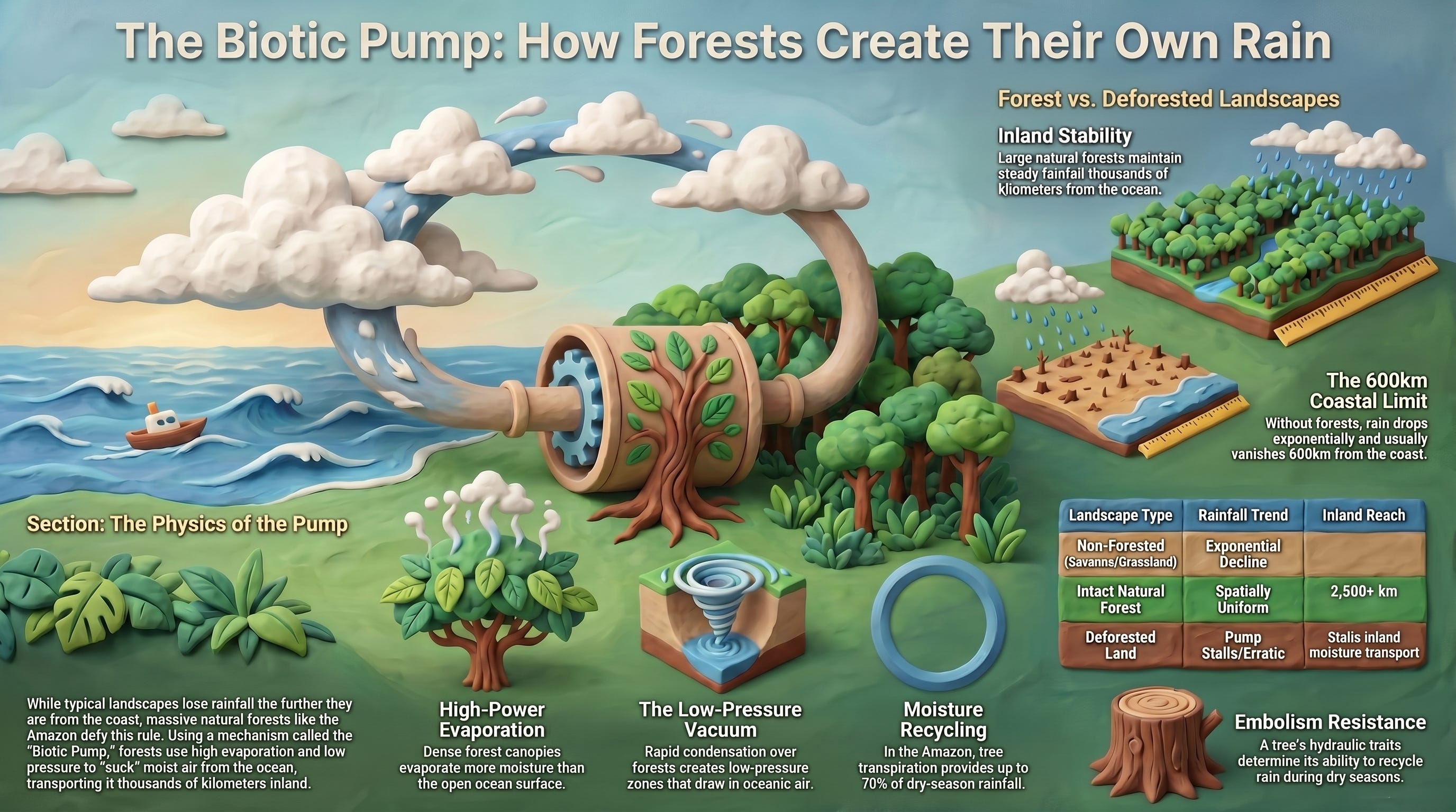
The forest is not background to the water cycle. The forest is the pump.
THE RIVER ABOVE THE RIVER
The phenomenon has several names. Brazilian researchers and science journalists have called them, rios voadores, flying rivers. Atmospheric scientists call them atmospheric rivers when they refer to the broader global category, though the Amazon’s flying rivers have specific characteristics worth distinguishing from the atmospheric rivers of the mid-latitudes that carry moisture off the Pacific toward California or off the Atlantic toward the British Isles.
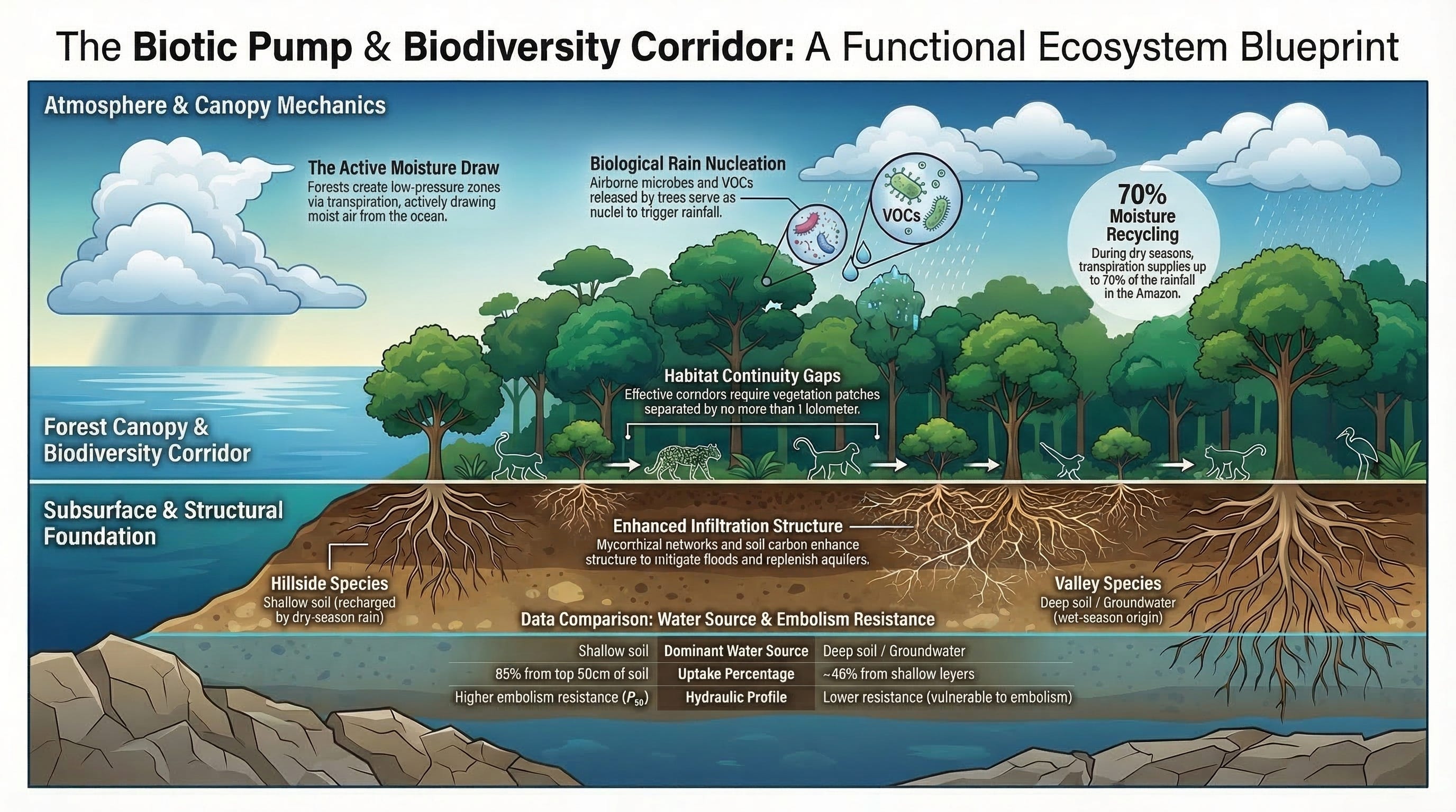
The mechanism begins at the root. An Amazonian tree is a water pump in the most literal sense. Its roots draw moisture from deep soil and shallow groundwater, move it upward through vascular tissue, and release it as water vapor through tiny pores in the leaves called stomata. A single mature Brazil nut tree can transpire several hundred liters of water per day. Multiply that by the four hundred billion trees of the Amazon basin, and the forest is moving an almost incomprehensible volume of water from soil to sky every day. It has been doing so, with the unbroken diligence of something that does not rest and does not take weekends, for tens of millions of years.
That vapor rises, cools, condenses into clouds, and releases heat, the latent heat of condensation, into the surrounding air. The heating drives atmospheric circulation. The moisture, now partly precipitated as rain and partly still vapor, travels further into the continent, where forest draws it back down through the same mechanism, and the cycle repeats. By the time moisture from the Atlantic arrives at the Andes, it may have been cycled through the forest and released into the sky five or six times.
The consequence is a rainfall distribution that defies the intuition you would build from looking at a standard climate map. Coastal regions near large bodies of water get a lot of rain. That makes sense, moisture evaporates from the ocean, winds carry it inland, it precipitates when it hits topography or when air masses cool. You would expect rainfall to decline as you move inland, away from the moisture source. And over non-forested terrain, it does.
But the Amazon is not non-forested terrain. Over the Amazon, rainfall holds remarkably steady as you move from the Atlantic coast into the deep interior, across close to three thousand kilometers of continent. The forest is maintaining its own rainfall. It is doing what no ocean, mountain range, or prevailing wind could do on its own. It is continuously recycling moisture and lifting it back into the atmosphere, sustaining precipitation far into the interior at rates that should, by the standard model of continental hydrology, be impossible.
The forest is not where rain happens to fall. The forest is what makes the rain fall there, and not somewhere else, and not not at all.
THE TOWN THAT SHOULD BE DRY
There is a small city called Leticia on the southern tip of Colombia, right at the Amazon River, at the meeting point of Colombia, Peru, and Brazil. It sits approximately three thousand kilometers from the Atlantic coast. If you drew a line on a map and marked where the trade winds originate and where they lose their moisture as they move inland, Leticia should be in a moisture shadow. The wet air from the Atlantic should have long since precipitated somewhere to the east. Leticia, by the physics of standard atmospheric circulation, should be considerably drier than it is.
Leticia receives roughly three thousand millimeters of rain per year. That is more rain than Fernando de Noronha, a tropical island sitting directly in the path of the Atlantic trade winds, six hundred kilometers off the coast of Brazil, surrounded by ocean on every side.
An island in the ocean gets less rain than a city three thousand kilometers inland.
This is the Leticia paradox, and it is not a quirk of local geography. It is a direct measurement of the forest doing its job. The moisture that falls on Leticia did not travel there from the Atlantic on a single uninterrupted journey. It evaporated from the Atlantic, precipitated over coastal forest, was absorbed by that forest’s roots, transpired back into the atmosphere, carried further inland, precipitated again, absorbed again, transpired again, and recycled through the biological machinery of the forest multiple times before it arrived, as rain, on the city at the edge of three countries.
Remove the forest, and the recycling stops. The moisture that would have made that journey precipitates early, runs off bare ground, flows to the sea, and does not return. The interior dries, not because the trade winds changed, not because the ocean changed, but because the pump stopped.
WHAT HAPPENS WHEN THE PUMP STOPS
The Amazon has lost approximately seventeen percent of its original forest cover, an area larger than France and Germany combined. That loss has not been evenly distributed. It has concentrated in the south and east, in what researchers call the arc of deforestation, where cattle ranching and soy agriculture have converted forest to pasture and cropland at rates that have, in some years, exceeded ten thousand square kilometers per year.
Brazilian climate scientists, including Antonio Nobre of the National Institute for Amazonian Research, have identified the tipping point threshold, somewhere between twenty and twenty-five percent forest loss, where the moisture recycling system may cross a boundary from which it cannot recover through regrowth alone. Beyond that threshold, the feedback loops that maintain the flying rivers [forest generates moisture, moisture sustains forest, forest generates more moisture] are disrupted sufficiently that the system shifts to a different stable state. A drier stable state. One in which the forest that remains cannot generate enough moisture to sustain the forest that remains.
The consequences of crossing that threshold are not abstract. The La Plata Basin, where Buenos Aires sits, where Brazil’s Mato Grosso do Sul raises cattle and soy, where Paraguay’s agricultural economy operates, receives half its rainfall from the Amazon’s flying rivers. A sustained disruption of those rivers would reduce agricultural water supply across a region that produces a significant fraction of the world’s beef, soy, and corn. Droughts that already strain the hydropower dams that supply a large portion of Brazil’s electricity would intensify. The economic consequences would be felt not just in South America but in global commodity markets, in food prices, in the downstream financing of agricultural infrastructure.
And this is not a problem that stays in South America. The atmospheric rivers of the Amazon connect to global circulation patterns in ways that researchers are still mapping. There is growing evidence that disruption of Amazon moisture cycling influences rainfall variability as far away as the midwestern United States and parts of sub-Saharan Africa. The planetary water system is more connected than any single region’s meteorology makes visible.
None of this is a prediction of a specific disaster on a specific date. Climate systems are not that legible. What the science says is that we are running an experiment on a system we depend on, in a direction we understand the risks of, without having solved the problem of reversing course once the threshold is crossed.
THE AMAZON IS NOT ALONE
It would be easier, in a certain sense, if the Amazon’s flying rivers were unique. If they were just a remarkable curiosity of the world’s largest rainforest, extraordinary but contained. They are not unique. Every major forest on earth is participating in some version of the same dynamic, at different scales and with different degrees of scientific documentation.
The Congo Basin rainforest, the second largest on earth, that straddles the equator across central Africa, generates moisture recycling that is less studied than the Amazon’s but structurally similar. The Congo forest’s evapotranspiration maintains rainfall across a vast interior region whose agricultural and ecological viability depends on moisture that the ocean alone could not deliver this far inland. Congo Basin deforestation, which has accelerated significantly in recent decades, is beginning to attract the kind of hydrological attention that the Amazon received twenty years ago. The data that is accumulating looks familiar.
South Asia’s monsoon system is among the most complex and consequential weather patterns on earth, delivering the rainfall that two billion people and the agricultural systems that feed them depend on. The role of Himalayan and Indian subcontinent forest cover in the monsoon’s behavior is not a simple one, the monsoon is driven primarily by the differential heating of land and ocean, but there is growing evidence that forest loss in the Himalayan foothills and the Indian subcontinent affects rainfall distribution in ways that the standard monsoon model does not capture. This is an area of active research rather than settled science.
In Siberia, the dynamics are different but the logic is recognizable. The boreal forest, the taiga, covers more land area than any other forest biome on earth. Its evapotranspiration contributes to the moisture cycling that maintains precipitation across the interior of the Eurasian continent. The Yenisey River basin, one of the largest river systems in the world, actually receives more precipitation at its interior reaches than at its Arctic coast! A pattern that, like the Leticia paradox, is not explained by standard atmospheric circulation but is consistent with a forest that is actively recycling and redistributing moisture.
The planetary picture, when you step back far enough to see it, is of an earth whose interior rainfall is maintained not only by winds from the ocean but by forests that catch that moisture, recycle it, and carry it further than any passive atmospheric process could. The forests are infrastructure. The most ancient and extensive water infrastructure on the planet, built over hundreds of millions of years, and currently being dismantled at a pace the infrastructure’s original builders, the trees themselves, cannot respond to.
THE PHYSICIST WHO ASKED WHY
By the early 2000s, the phenomenon was documented. The Amazon’s flying rivers had been measured. The Leticia paradox had been published. The precipitation data showing coast-to-interior stability over forested regions, and the absence of that stability over non-forested regions, existed in the peer-reviewed literature. What was missing, what the mainstream of atmospheric science had not supplied, was a physical mechanism that explained why forests did not merely add moisture to the atmosphere but actively drew ocean air inland.
The conventional model of atmospheric circulation held that air movement was primarily a thermal phenomenon: warm air rises, creating low pressure, cooler denser air flows in from the sides to fill the gap, and the resulting circulation patterns carry moisture from the ocean across the land. In this model, the forest is a passive beneficiary of the circulation, not a driver of it. Moisture arrives from the ocean because the wind brings it. The forest uses it. The question of what happens to the moisture after the forest uses it was not, in this framing, a question that changed the model in any fundamental way.
In 2007, a paper appeared in the journal Hydrology and Earth System Sciences from two researchers at the Petersburg Nuclear Physics Institute in St. Petersburg, Russia. Their names were Victor Gorshkov and Anastassia Makarieva. The paper proposed a different mechanism.
Gorshkov had spent decades developing what he called biotic regulation theory, the proposition that living organisms do not merely adapt to their environment but actively regulate it, maintaining the conditions for their own survival through collective feedback mechanisms that operate at ecosystem scale. He had asked a foundational question, If organisms can evolve lungs to move oxygen to where it is needed, is it not possible that ecosystems evolve mechanisms to move water to where it is needed? Anastassia Makarieva , who came to him as a PhD student in atmospheric physics, had spent years working through the mathematics of what such a mechanism might look like.
What they proposed, what is now called the biotic pump, turns on the physics of condensation. When water vapor condenses into liquid water, it undergoes a phase transition: a gas becomes a liquid that occupies roughly a thousand times less volume. This reduction in volume creates a local drop in air pressure above the condensation zone, and pressure drops draw air in from surrounding regions. If a forest is generating condensation continuously and at large scale, [which forests do because their enormous transpiration rates load the air above them with vapor that condenses as it rises and cools] then the forest is generating a persistent low-pressure system above itself. That low pressure draws moist air in from the ocean. Not passively, following existing circulation patterns, but actively, through the physics of condensation, creating the very circulation that brings the moisture to the forest in the first place.
The forest, in this model, is not a beneficiary of the wind. The forest is part of what makes the wind.
The reception of the biotic pump in the broader scientific community has been complicated, and being honest about that complication matters. Several prominent atmospheric scientists have disputed the magnitude of the pressure differential that Makarieva and Gorshkov proposed, arguing that the condensation-induced pressure drop is too small to drive the circulation patterns they describe. The theory has had difficulty breaking into the highest-tier journals. A Science magazine profile in 2012 captured Makarieva’s position with a phrase that has stayed with her work. She was, it said, an outsider in every direction, a physicist working in atmospheric science, a Russian working in a field led by Western institutions, a woman in a field historically dominated by men, and publishing from a nuclear physics institute on questions that most climate modelers considered settled.
What has not been disputed is the observational record. The precipitation data that the biotic pump predicts, coast-to-interior rainfall stability over forested regions, the absence of that stability over non-forested regions, and the anomalies like Leticia and the Yenisey, exist in the data whether or not the biotic pump mechanism is the correct explanation for them. Douglas Sheil, a professor of forest ecology at the Norwegian University of Life Sciences and one of the more prominent Western scientists to engage seriously with Makarieva’s work, has said publicly that his review of the evidence leads him to believe the biotic pump is correct. Antonio Nobre, among Brazil’s leading Amazon climate scientists, has incorporated the biotic pump into his understanding of Amazon hydrology. By 2022, the broader proposition, that forests actively influence atmospheric moisture transport, not merely as a source of vapor but as a driver of circulation, had moved from the margins toward a contested but legitimate position in the literature.
Gorshkov died in 2024. Makarieva still works at the Petersburg Nuclear Physics Institute. She maintains a Substack called Biotic Regulation and Biotic Pump and appeared in 2025 on The Great Simplification podcast, where she spent two hours explaining the theory and its implications to a non-specialist audience with the patience of someone who has been explaining something important that people weren’t ready to hear for a very long time. She is not bitter. She is precise. The data, she has said in various forums, does not require the mainstream to accept her mechanism in order to be true. They are true. The mechanism is the question that remains open.
The data does not require the mainstream to accept her mechanism in order to be true. The pattern is in the measurements. The argument is about why.
THE FOREST THAT CALLED THE RAIN BACK
The abstract becomes concrete in Rajasthan.
Rajasthan is the largest state in India and among its driest. It contains the Thar Desert, it borders Pakistan, and for much of the late twentieth century it was losing ground, literally, as vegetation cover shrank, as rivers ran dry, as the water table dropped and kept dropping and the horizon of viable agriculture contracted year by year. This was the direction things moved.
In the 1980s, a man named Rajendra Singh began working with villages in the Alwar district to restore johads, traditional crescent shaped, earthen, water harvesting structures that Rajasthani communities had used for centuries to slow monsoon runoff and allow it to percolate into the soil. The johads had fallen into disuse so Singh and the villagers rebuilt them. They planted trees and they protected existing vegetation from livestock grazing. They did the slow, unglamorous work of giving the land back its capacity to hold water.
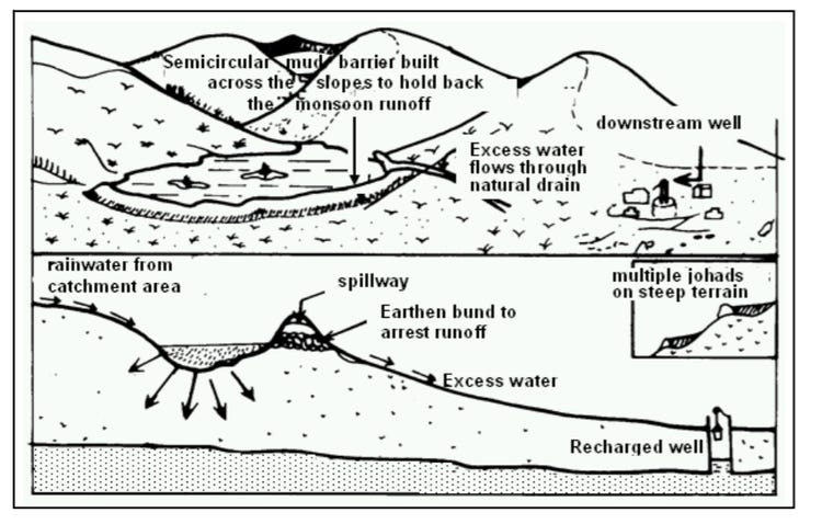
The results, documented over the following two decades, went beyond what the standard model of water management would have predicted. Five rivers in the region that had been dry for years, the Arvari, the Ruparel, the Sarsa, the Bhagani, and the Jahajwali, began flowing again. The water table in surrounding areas rose. Regional temperatures dropped by approximately two degrees Celsius. Vegetation cover in restored watersheds increased from roughly two percent to close to fifty percent. Farmers who had left for cities returned.
This is not a model output. It is not a projection. It happened, in a place with a name, to people whose names are recorded. The physics that made it possible are the same physics that operate over the Amazon, over the Congo, over the boreal forest of Siberia. It is just at a scale legible to a single human lifetime and a single state’s geography.
Singh received the Stockholm Water Prize in 2015, an award sometimes described as the Nobel Prize of water. That recognition matters not because awards validate physics but because it brought documentation and international scientific scrutiny to what the villages of Alwar district had already demonstrated with shovels and time.
The pattern the biotic pump predicts, that restoring vegetation restores water, shows up at village scale in Rajasthan as clearly as it shows up in the precipitation records of the Amazon basin. The mechanism may still be debated. The outcome keeps arriving at the same destination.
The Amazon’s flying rivers are moving above trees right now, carrying more water than the Amazon River. The question of what made them, and what keeps them flowing, is the question that the next article in this series follows back in time, to a continent that was wetter than we think, and a landscape that we have been simplifying without knowing the cost.
Continue reading:
The Map That Disappeared: Before the Dust Bowl, before the plow, the interior of North America was a different hydrological world. The journals of Lewis and Clark, the land survey records, and the rings of ancient trees all tell the same story. . . In the next article.
SOURCES
Amazon flying rivers flow rate and La Plata Basin rainfall contribution: Marengo et al. (2012), Journal of Climate; Arraut et al. (2012), Journal of Hydrometeorology. Amazon moisture recycling and Leticia precipitation data: Eltahir and Bras (1994); Salati and Vose (1984). Amazon deforestation tipping point: Lovejoy and Nobre (2018), Science Advances; Nobre et al. (2016), PNAS. Biotic pump theory: Makarieva and Gorshkov (2007), Hydrology and Earth System Sciences; Makarieva et al. (2013), Atmospheric Chemistry and Physics. Biotic pump scientific reception: Sheil and Murdiyarso (2009), BioScience; Science magazine profile of Makarieva (2012). Yenisey Basin precipitation gradient: cited in Makarieva et al. peer-reviewed responses. Congo Basin hydrology: Alsdorf et al. (2016) and subsequent literature. Rajendra Singh / Rajasthan restoration: Stockholm Water Prize documentation (2015); Tarun Bharat Sangh organizational records; Agarwal and Narain (1997), Dying Wisdom, Centre for Science and Environment.
Pen & Root · penandroot.carrd.co · WHEN THE FOREST CALLS THE RAIN · ARTICLE 3 OF 7